BMKG Monitors Tropical Cyclone Mekkhala in Northeastern Philippines
BMKG Monitors Tropical Cyclone Mekkhala in Northeastern Philippines BMKG Monitors Tropical Cyclone Mekkhala in Northeastern - The Meteorology, Climatology
BMKG Monitors Tropical Cyclone Mekkhala in Northeastern Philippines
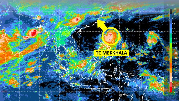
Tempatdonasi.com – The Meteorology, Climatology, and Geophysics Agency (BMKG) has identified Tropical Cyclone Mekkhala as a developing storm in the northeastern region of the Philippines. This system, which originated from a low-pressure area classified as 92W, has now advanced toward the Tropical Cyclone Warning Center (TCWC) in Jakarta. The BMKG issued updates on Tuesday afternoon, June 23, 2026, confirming the cyclone’s presence and outlining its projected behavior. As the storm continues to evolve, officials are closely tracking its movement and potential effects on surrounding areas.
Formation and Early Development
Tropical Cyclone Mekkhala emerged from the remnants of a previously active system, Tropical Cyclone 92W, which gained strength as it moved toward the TCWC. The formation of such cyclones typically begins with the convergence of warm ocean waters, atmospheric instability, and favorable wind patterns. In this case, the system intensified due to the warm temperatures of the Philippine Sea, which provide the necessary energy for tropical cyclones to develop. BMKG analysts noted that while Mekkhala’s maximum wind speed is expected to decline over the next 24 hours, its intensity remains formidable, maintaining a Category Four classification.
“The maximum wind speed of Tropical Cyclone Mekkhala is predicted to decrease in the next 24 hours. ‘But the intensity is still in category four with a movement towards the northwest,’ as stated in the BMKG’s official statement on Tuesday afternoon, June 23, 2026.”
The Category Four designation indicates that the cyclone is capable of generating winds exceeding 140 kilometers per hour (87 miles per hour). Such wind speeds can lead to significant damage, including uprooting trees, snapping power lines, and overturning vehicles. The northwestward trajectory of Mekkhala suggests a possible interaction with the coastal regions of the Philippines, which could trigger heavy rainfall and storm surges. BMKG’s vigilance in monitoring the system is critical, as early warnings can mitigate risks to both land and sea.
Impact on Indonesian Waters
Although Mekkhala is primarily a Philippine phenomenon, its influence is not limited to the archipelago. The BMKG has warned that the cyclone may have an indirect effect on Indonesian waters, particularly in the southern regions. This is due to the potential for strong winds to generate waves that could reach heights of 1.25 to 2.5 meters. These waves are anticipated to affect key maritime areas, including the Sangihe Islands-Talaud Islands, the Maluku Sea, and the North Maluku Pacific Ocean.
The Maluku Sea, a vital shipping route, is especially vulnerable to such weather conditions. Mariners navigating these waters must be prepared for increased wave activity, which could complicate operations and pose hazards to vessels. Similarly, the Sangihe-Talaud region, known for its fishing and tourism industries, may experience disruptions in daily activities. BMKG has advised local authorities and residents to remain cautious, as even indirect impacts can lead to coastal erosion or minor flooding in low-lying areas.
High Wave Warnings and Maritime Safety
Alongside the wave forecasts for Indonesian waters, BMKG has issued an early warning about high waves that could reach 2.5 to 4 meters in several maritime zones. These waves are expected to appear in regions such as the western Indian Ocean off the coasts of Bengkulu and Lampung, as well as the southern Indian Ocean near Banten and West Java. The agency emphasized that these conditions may create dangerous scenarios for ships and offshore structures.
“The potential of high waves in those areas may pose a risk to maritime safety,” according to BMKG’s statement.
High waves of this magnitude can lead to severe turbulence, reducing visibility and increasing the likelihood of collisions or capsizing incidents. In particular, the southern Indian Ocean off Banten and West Java is a crucial area for commercial fishing and cargo transport. The BMKG’s early warning system aims to provide sufficient time for vessels to adjust their routes or take shelter in calmer waters. This proactive approach is essential for preventing accidents and safeguarding lives.
Regional Forecast and Timeline
The BMKG’s predictions span from June 23 to June 26, highlighting the duration of the wave activity. During this period, the western Indian Ocean near Bengkulu and Lampung will see high waves, which could last for several days. Meanwhile, the southern Indian Ocean off Banten and West Java is also expected to experience similar conditions. Additionally, the southern sea of Yogyakarta, part of Indonesia’s central region, may see wave activity that could impact coastal communities.
The timeline of these weather events underscores the need for continuous monitoring. While the cyclone’s direct path may shift, its residual effects can extend across multiple maritime regions. For instance, the Maluku Sea, which lies west of the Philippines, is likely to face the brunt of the waves as the system moves northwest. This area is a hotspot for maritime traffic, and the BMKG’s updates will help ensure that ships and fishing boats are well-prepared for the conditions.
Broader Implications and Preparedness Measures
Tropical Cyclone Mekkhala’s development and movement highlight the dynamic nature of weather systems in the region. The Philippines, situated in the Pacific typhoon belt, experiences frequent cyclonic activity, particularly during the rainy season. Mekkhala’s presence serves as a reminder of the importance of meteorological monitoring and disaster preparedness. BMKG has been actively engaging with local authorities and coastal communities to disseminate information and coordinate response efforts.
Preparedness measures include reinforcing infrastructure, evacuating at-risk populations, and ensuring that emergency services are on standby. The agency has also collaborated with international meteorological bodies to share data and enhance forecasting accuracy. These steps are part of a broader strategy to minimize the impact of cyclones on both human and economic activities. Additionally, the BMKG has highlighted the need for public awareness, as timely information can empower individuals to take necessary precautions.
While the cyclone’s intensity is expected to decrease slightly in the coming days, its northwestward movement means it will remain a significant weather event for a prolonged period. This trajectory may lead to interactions with other weather systems, potentially influencing the monsoon patterns in Southeast Asia. The BMKG’s ongoing assessments are vital for providing updated forecasts and ensuring that all stakeholders are informed about the evolving situation.
The development of Mekkhala also raises questions about climate change and its effect on cyclone frequency and strength. Scientists have observed a trend of more intense storms in recent years, driven by rising sea temperatures and shifting atmospheric conditions. BMKG’s role in tracking such trends is crucial for long-term planning and resource allocation. By maintaining a close watch on the cyclone’s progression, the agency contributes to the safety of millions who live in the region’s coastal zones.
As the storm continues to move, the BMKG will likely issue further updates, refining its predictions based on real-time data. These updates