
Philippines: Large Mindanao Quake Displaced Roughly 20,000
Philippines: Major Earthquake in Mindanao Displaces Over 20,000 Philippines - On Tuesday, emergency teams persisted in their efforts to survey ruined and
Philippines: Major Earthquake in Mindanao Displaces Over 20,000
Tempatdonasi.com – On Tuesday, emergency teams persisted in their efforts to survey ruined and partially collapsed structures in General Santos city and nearby regions, following a powerful earthquake that struck the Philippines earlier in the week. The disaster, which occurred on Monday, marked the most severe seismic event of the year, resulting in 37 fatalities and displacing approximately 20,000 individuals. The Office of Civil Defense reported that only four people remained unaccounted for in the southern provinces of Mindanao, yet several buildings that had crumbled or sustained significant damage required further investigation to determine if any survivors or additional casualties were still trapped.
Search and Rescue Operations Intensify
President Ferdinand Marcos Jr. activated key officials from Manila to assist in the coordination of relief efforts. These experts were tasked with overseeing search-and-rescue initiatives, distributing essential supplies such as food and construction materials, and evaluating the condition of critical infrastructure like bridges and roads. The deployment aimed to streamline response efforts and ensure a swift recovery for affected communities.
Quake Details and Casualties
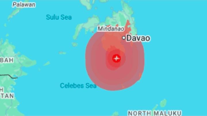
Authorities updated the confirmed death toll to 37 on Tuesday, with nearly 500 individuals injured. The majority of displaced residents sought refuge in temporary shelters, as the earthquake’s aftermath left their homes in disarray. The tremor, measuring 7.8 on the Richter scale, initially prompted a tsunami alert, leading to evacuations from coastal areas. However, the actual waves that reached the shoreline were relatively minor, peaking at 1.4 meters above normal tide levels.
Smaller tsunami waves were recorded in distant locations such as Indonesia, Palau, and southern Japan. The epicenter of the quake was located near the southern coast of Mindanao, an island renowned for its significant population and economic activity. General Santos, a city with a population of around 700,000, served as a focal point of the disaster, with many of its residents affected by the destruction.
Impact on Local Communities
General Santos suffered particularly hard, with at least 13 lives lost due to collapsed buildings and falling debris. In the mountainous town of Glan, located slightly south of the epicenter, a landslide triggered by the quake buried multiple homes, contributing to 18 fatalities in Sarangani province. Rafaelito Alejandro, a representative of the Office of Civil Defense, noted that the majority of these deaths were caused by the landslide, which swept through the area with alarming speed.
Additional casualties were documented in the southern provinces of South Cotabato and Davao Occidental, as well as on Balut Island, a small landmass off the southeastern coast of Mindanao. The quake’s effects were felt across the region, with officials emphasizing the need for continued vigilance in areas where buildings had sustained structural damage.
Infrastructure and School Damage
Initial government assessments indicated that roughly 2,000 residential homes and 117 public buildings were damaged or partially collapsed in the affected provinces. The international airport in General Santos remained closed for the day, causing the cancellation of 63 domestic flights. However, flights transporting humanitarian aid were permitted to continue, ensuring that relief supplies reached the hardest-hit areas.
Notably, the earthquake occurred on the first day of school after a two-month summer break, leaving many students among the injured. Officials highlighted the risk of aftershocks, which could compromise the safety of damaged school structures. As a result, approximately 6,000 public school buildings were flagged for inspection before reopening, with Alejandro stating,
“We cannot force the immediate reopening of schools because we have to ensure the integrity of buildings.”
Aftershocks and Ongoing Threats
Following the main quake, the US Geological Survey recorded over a dozen aftershocks in the region, several of which exceeded magnitude 5. These tremors were more frequent and intense in the immediate aftermath, adding to the uncertainty for survivors. The continued activity of the fault lines underscored the urgency of the situation, with emergency teams working tirelessly to locate trapped individuals and assess the full extent of the damage.
Historical Context of Seismic Activity
The Philippines, situated along the Pacific “Ring of Fire,” frequently experiences earthquakes and volcanic eruptions due to its tectonic location. Monday’s quake was identified as the most significant in the country’s recorded history in 50 years by Teresito Bacolcol, director of the Philippine Institute of Volcanology and Seismology. This seismic zone has witnessed major disasters in the past, including a magnitude 8.1 earthquake that struck the Cotabato Trench on August 17, 1976, resulting in 8,000 deaths. That event also generated massive tsunamis, reaching heights of 8 to 10 meters, which devastated coastal towns.
Another notable incident occurred in 1990, when a 7.8-magnitude earthquake caused widespread destruction, claiming over 1,000 lives and injuring thousands. These historical events highlight the region’s vulnerability to large-scale seismic activity and the importance of preparedness. The current disaster, while less severe than those in the past, has once again demonstrated the Philippines’ susceptibility to earthquakes, especially in densely populated and infrastructure-heavy areas like General Santos.
Humanitarian Response and Recovery Efforts
Efforts to support quake victims have been a top priority, with officials coordinating the distribution of food, shelter, and medical supplies. The Civil Defense office emphasized that the focus of the relief operations would remain on rescuing survivors and providing immediate aid to affected families. Meanwhile, engineers and structural experts worked to evaluate the stability of damaged buildings, ensuring that they could safely accommodate returning residents.
Public concern has also grown as the scale of the disaster becomes clearer. With over 20,000 people displaced, local authorities are preparing for the long-term challenges of housing, sanitation, and economic recovery. The situation has prompted a renewed emphasis on disaster resilience, particularly in regions prone to seismic activity. As the country grapples with the aftermath, the global community has been monitoring the event, with media outlets like Tempo providing updates on the unfolding crisis.
Broader Implications for the Region
While the immediate focus remains on the Philippines, the earthquake’s ripple effects have been noted in neighboring areas. The tsunami warning, though short-lived, prompted widespread precautionary measures, including the evacuation of coastal communities. This event has also sparked discussions about the interconnectedness of seismic activity across the Pacific Rim, with experts noting that similar tremors in the region can trigger secondary hazards such as tsunamis and landslides.
As the search for survivors continues, the resilience of the affected communities and the effectiveness of the relief response will be critical factors in determining the long-term impact of the disaster. The combination of natural calamities and the region’s exposure to the Ring of Fire underscores the need for sustained investment in infrastructure and emergency preparedness. For now, the focus remains on rescue operations, with hopes of minimizing further loss of life and providing adequate support to those in need.
Additional Resources
For more information on the effects of the Philippines’ recent seismic activity, readers are encouraged to explore related articles. The latest updates from Tempo are available on Google News, offering insights into the ongoing recovery efforts and the broader implications of this earthquake for the region.