
Which 5 Indonesian Volcanoes Are Showing Increased Activity? Anak Krakatau Among Them
Which 5 Indonesian Volcanoes Are Showing heightened unrest right now? Indonesia's position along the Pacific Ring of Fire keeps more than 400 active volcanoes
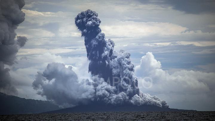
Which 5 Indonesian Volcanoes Are Showing Increased Activity
Tempatdonasi.com – Which 5 Indonesian Volcanoes Are Showing heightened unrest right now? Indonesia’s position along the Pacific Ring of Fire keeps more than 400 active volcanoes in constant geological motion, and early September 2026 brought a rare cluster of simultaneous alerts. Within a single week, five peaks — Anak Krakatau in the Sunda Strait, Mount Ibu in North Maluku, Mount Sinabung in North Sumatra, Mount Semeru in East Java, and Lewotobi Laki-Laki in East Nusa Tenggara — erupted or registered sharply elevated activity. The Center for Volcanology and Geological Hazard Mitigation (PVMBG) has tightened surveillance on all five and asked residents, hikers, and tourists to observe updated exclusion zones without exception.
The threat profile differs from one summit to the next. Some vents are throwing sustained ash columns and Strombolian bursts; others carry the risk of pyroclastic flows or sudden lava avalanches. For villages nestled in these mountains’ shadows, the line between a routine gas puff and a genuinely dangerous event can hinge on minutes of observation, which is precisely why PVMBG’s tiered alert designations shape daily routines from school schedules to market-day travel plans.
Anak Krakatau and Mount Ibu: Back-to-Back Events in the Western and Eastern Archipelago
Anak Krakatau, the youngest member of the Krakatau volcanic family, had been inflating since early August according to tiltmeter data from the Tanjung Station. That pressure release arrived as a multi-day eruptive episode spanning the night of September 4 through early September 6, 2026. CCTV feeds logged a vivid red-hued column after dark and darker, blackish plumes in daylight, with visibility around the cone mostly clear but intermittently obscured by fog. The sequence closed with a discrete Strombolian-type burst at 3:53 a.m. on September 6, lasting roughly thirty seconds. PVMBG tentatively read that final event as the terminal pulse of the preceding continuous episode. Instrumental traces backed the interpretation: the Real-time Seismic Amplitude Measurement (RSAM) average spiked briefly on September 5 before easing the next day, while Lava93 Station readings stayed comparatively flat throughout. Anak Krakatau remains at Level III (Alert), and the public must stay outside a three-kilometer radius of the active center.
On the morning of September 6, Mount Ibu in North Maluku vented an ash column reaching approximately 600 meters above its summit crest, placing the plume top near 1,925 meters above sea level. The white-to-gray column, of moderate-to-thick density, drifted northward. Seismographs captured the event with a peak amplitude of 28 millimeters over an initial duration of about 44 seconds. Ibu currently sits at Level II (Advisory), a tier below Alert, yet PVMBG still advises against any activity within two kilometers of the crater and within a 3.5-kilometer sectoral extension oriented toward the northern crater opening. Outdoors workers and nearby residents are counseled to wear masks and eye protection should ashfall materialize, and local authorities have urged communities to stay calm, disregard unverified rumors, and follow official guidance.
Sinabung, Semeru, and Lewotobi Laki-Laki: Eastern Sumatra Through East Nusa Tenggara
Mount Sinabung in Karo Regency, North Sumatra, was elevated to Level III (Alert) at noon on September 6 after PVMBG observers logged dense white crater smoke ascending 300 to 500 meters above the summit. Drone surveys found no evidence of fresh lava-dome growth at the eruption vent, and no rockfall earthquakes linked to destabilization of the older dome were detected — a sign the existing structure holds steady. Shallow-depth earthquakes associated with magma supply and rising pressure continued to register, though their frequency was not considered significant. Under the revised guidance, the general exclusion zone stands at three kilometers from the summit, while the sectoral radius to the southeast has been trimmed from six kilometers to five. Residents and visitors are told to avoid both zones.
Mount Semeru, straddling the boundary between Lumajang and Malang regencies in East Java, erupted at 7:15 a.m. on September 6. The blast hurled an ash column roughly 1,000 meters above the Mahameru summit. The plume, white to gray and of thick intensity, tracked eastward. Seismographic traces recorded a maximum amplitude of 23 millimeters over a duration of 102 seconds. Semeru retains its Level III (Alert) classification, and PVMBG has reiterated that no one should approach within the designated danger perimeter until the alert is downgraded.
Lewotobi Laki-Laki in East Nusa Tenggara rounded out the five-peak cluster, registering elevated activity that prompted PVMBG to intensify monitoring and issue updated advisories to local communities. Specific exclusion parameters for this summit are communicated through district-level disaster-management offices and should be checked before any travel or fieldwork in the area.
For residents and visitors near any of these five volcanoes, the single most important step is to check the current PVMBG alert level and exclusion-zone map before heading outdoors. Alert levels can shift within hours, and the boundaries that protect you today may differ from those in effect tomorrow.
FAQ: Practical Questions About the September 2026 Volcanic Cluster
How often does PVMBG update alert levels during an active episode? During sustained unrest, PVMBG reviews seismic, tilt, and gas data continuously and can revise an alert level within hours. District disaster-management offices relay changes through local radio, social-media channels, and village heads.
What should I do if ashfall reaches my area? Wear a dust mask and eye protection, close windows and doors, cover water storage, and follow instructions from local authorities. Do not drive through dense ash unless necessary, and keep vehicles’ air filters clean.
Can I still visit the surrounding regions for tourism? You may travel to areas outside the posted exclusion zones, but verify the current alert level with PVMBG or your district disaster-management office before departure. Conditions can change rapidly, and road closures are common near active vents.
Where can I find the latest exclusion-zone maps? PVMBG publishes updated maps through its official channels and through district-level BPBD (disaster-management) offices. Local radio stations and village heads also distribute printed summaries during active episodes.