Jakarta Reports No Damage After M6.5 Quake Hits Seribu Islands
Authorities in Jakarta’s Seribu Islands confirmed that no casualties, building damage, or environmental disruption had been identified after a magnitude 6.5
Seribu Islands Remain Safe Following Magnitude 6.5 Earthquake
Tempatdonasi.com – Authorities in Jakarta’s Seribu Islands confirmed that no casualties, building damage, or environmental disruption had been identified after a magnitude 6.5 earthquake struck near the island chain early on Saturday, September 12.
The tremor occurred at 4:23 a.m. local time, when many residents were still at home. While shaking was felt in several island communities, daily life continued as normal and officials found no sign of damage across the regency’s six administrative areas.
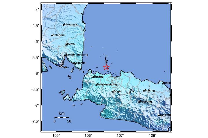
The Meteorology, Climatology and Geophysical Agency (BMKG) placed the epicenter roughly six kilometers southeast of the Seribu Islands, at 5.81 degrees south latitude and 106.56 degrees east longitude. The quake originated at a depth of 376 kilometers, and BMKG said it did not present a tsunami risk.
Residents and Visitors Face No Reported Disruption
Munawar, a member of the Seribu Islands regency administration, said the earthquake did not create a significant impact for residents or the local environment. Many people did not notice the event when it happened and only became aware of it later through news coverage.
“The islands remain safe. There was no felt impact from the earthquake. Most, if not all, residents did not feel the earthquake directly and instead learned about it through media reports,” Munawar said in Jakarta on Sunday, September 13.
He added that the islands remained open and safe for tourism. The Seribu Islands, located north of Jakarta in the Java Sea, are a popular destination for short trips from the capital, with communities spread across numerous small islands.
Local authorities stressed that visitors could continue traveling to the area. Their assessment followed coordination among village officials, neighborhood representatives, the Indonesian military, police, and other relevant agencies.
Monitoring Covers Six Administrative Areas
The Seribu Islands Regional Disaster Management Agency, or BPBD, carried out field monitoring after the earthquake to assess the condition of residents, infrastructure, and surrounding areas. Its checks found that normal activities were continuing and that no residents had been recorded as affected.
In Pulau Kelapa and Pulau Harapan, residents did not experience noticeable effects from the tremor. Some people in Pulau Panggang felt the shaking, but officials found no resulting damage.
Conditions were similarly stable in Pulau Tidung. In Pulau Pari, residents described shaking that lasted for approximately five seconds. Some residents of Pulau Untung Jawa also felt the earthquake. Despite those reports, there was no identified harm to buildings or the environment in either location.
Yusuf, the head of Pulau Pari village, said the response involved local coordination intended to ensure that conditions on the islands remained clear and secure for the public.
“Residents did not feel the impact, and the environment is also safe. So, the Seribu Islands are safe to visit, especially Pulau Pari,” Yusuf said.
The absence of visible damage is especially notable given the earthquake’s magnitude. Earthquake effects can differ substantially from one place to another, depending on depth, distance from the epicenter, local ground conditions, and the type of structures in an affected area. In this case, the quake’s deep origin and the lack of tsunami potential were key elements in the official assessment of immediate risk.
Authorities Continue Watching Seismic Updates
Although no emergency impacts were found, the BPBD said it would continue following earthquake information issued by BMKG and the Jakarta provincial disaster management agency. Continued monitoring allows local authorities to relay updates if seismic conditions change or if later reports require further checks.
For island residents and tourists, the official findings mean there was no indication of a disruption to routine activities, travel, or local services following the Saturday morning tremor. The assessment also offered reassurance to communities that felt brief shaking but saw no physical effects afterward.
Jakarta’s Seribu Islands consist of scattered islands and coastal settlements that depend on close communication between local administrations and emergency-response agencies. After an earthquake, those channels are used to verify conditions on each inhabited island, confirm whether residents need help, and inspect possible impacts on public facilities and the natural environment.
Officials found no such impacts in the latest event. Residents in the areas where shaking was felt were able to continue their normal routines, while locations where the quake was not felt also remained unaffected.
The Seribu Islands administration and disaster-management authorities will remain attentive to updates from BMKG. For now, the official assessment is that the island chain is safe, no damage has been recorded, and visitors may continue to travel to destinations including Pulau Pari.
Related Reading
Frequently Asked Questions
What is Jakarta Reports No Damage After M6 5?
Jakarta Reports No Damage After M6 5 is the main topic of this guide. The article explains the context, practical details, and next steps readers should understand.
Why does Jakarta Reports No Damage After M6 5 matter?
Jakarta Reports No Damage After M6 5 matters because readers are looking for a useful answer, not just a short summary. Good content should match search intent and help them decide what to do next.