
BMKG Detects 4,028 Hotspots Across Sumatra
More than 4,000 hotspots were identified across Sumatra on Tuesday, September 15, highlighting a broad fire-risk situation that is also affecting visibility
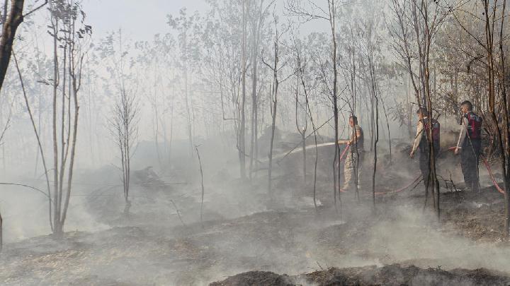
South Sumatra Leads as Thousands of Fire Hotspots Appear Across Sumatra
Tempatdonasi.com – More than 4,000 hotspots were identified across Sumatra on Tuesday, September 15, highlighting a broad fire-risk situation that is also affecting visibility and air quality in parts of Riau Province.
The Pekanbaru station of the Meteorology, Climatology, and Geophysics Agency (BMKG) recorded 4,028 hotspots in its update at 4:00 p.m. Western Indonesian Time. South Sumatra accounted for the overwhelming majority, with 2,994 hotspots detected.
Hotspots are thermal signals observed by satellite instruments and can indicate areas with unusually high heat. They may be associated with vegetation, land, or forest fires, although each detection still requires assessment on the ground to establish its precise cause and scale.
Hotspots Spread Across Multiple Provinces
Beyond South Sumatra, sizable numbers were identified in Bangka Belitung, where 354 hotspots were recorded, and Jambi, with 319. Lampung registered 269 hotspots, while Riau had 40 and Bengkulu had 32.
Smaller totals were also observed elsewhere on the island. West Sumatra recorded 13 hotspots, the Riau Islands had five, and North Sumatra had two.
Bella R. Adelia, a forecaster at BMKG Pekanbaru, detailed the distribution of detections in Riau, where six areas showed hotspots. Indragiri Hulu Regency had the largest number in the province, with 24. Indragiri Hilir followed with seven, Kuantan Singingi with four, and Pelalawan with three. Dumai City and Rokan Hilir each registered one hotspot.
“Other regions in Sumatra where hotspots were detected include West Sumatra (13), North Sumatra (2), and the Riau Islands (5),” she said.
The concentration in South Sumatra is notable because it represents nearly three-quarters of the island-wide total. At the same time, the spread across several provinces underscores that the issue is not confined to a single location. Monitoring conditions province by province remains important, particularly where dry weather, wind direction, and fire activity can combine to affect nearby communities.
Haze Reduces Visibility in Riau
The hotspot count coincided with haze in several parts of Riau. By 4:00 p.m. WIB, visibility in Pekanbaru and Rengat had fallen to roughly three kilometers.
Pelalawan had visibility of 2.5 kilometers, while Tambang recorded approximately four kilometers. Reduced visibility can complicate travel and daily outdoor activity, especially when haze becomes thicker or conditions change over a short period.
“Meanwhile, visibility in Pelalawan is 2.5 kilometers, and in Tambang, it is around four kilometers,” she explained.
Visibility readings describe how far a person can see clearly under prevailing atmospheric conditions. Haze can limit that distance when fine particles and smoke remain suspended in the air. Such conditions are particularly relevant for road users, local residents, and anyone whose work requires sustained time outdoors.
People in affected areas can monitor local weather and air-quality information, reduce unnecessary exposure to smoky conditions where possible, and take extra care when travelling. Changes in wind and rainfall can alter haze patterns, meaning conditions may vary between districts even within the same province.
Winds Carry Smoke Toward Riau
BMKG Pekanbaru said the haze affecting Riau is linked in part to smoke moving northward from fires in southern Sumatra. Winds from the southeast and southwest are contributing to that movement.
The weather agency emphasized that haze observed in Riau cannot be attributed only to sources within the province. Smoke can travel across administrative boundaries when carried by prevailing winds, making regional monitoring essential during periods of widespread fire activity.
“Based on the wind patterns and smoke distribution imagery we have monitored, there is a potential for smoke drifting in from areas south of Riau. Since smoke moves with the wind, the conditions observed in Riau are not solely influenced by sources located within the province itself,” stated Warjono, Head of the BMKG Pekanbaru Station.
This movement helps explain why a province with 40 detected hotspots can still experience haze influenced by fire activity elsewhere. The much larger number of hotspots in southern parts of Sumatra, particularly South Sumatra, provides important context for the smoke pattern being monitored in Riau.
Satellite hotspot data, visibility measurements, wind observations, and smoke-distribution imagery each provide different pieces of the picture. Together, they help forecasters assess where haze may be moving and which areas could face deteriorating conditions.
For residents, the key issue is that air and visibility conditions may be shaped by fires both nearby and far beyond their immediate surroundings. Continued observation of weather patterns and official advisories will be important as authorities track hotspots and the movement of smoke across Sumatra.
Related Reading
Frequently Asked Questions
What is BMKG Detects 4 028 Hotspots Across?
BMKG Detects 4 028 Hotspots Across is the main topic of this guide. The article explains the context, practical details, and next steps readers should understand.
Why does BMKG Detects 4 028 Hotspots Across matter?
BMKG Detects 4 028 Hotspots Across matters because readers are looking for a useful answer, not just a short summary. Good content should match search intent and help them decide what to do next.