BMKG Warns of High Waves in Lombok Strait Over the Next Week
Maritime activity around the Lombok Strait faces heightened risks in the coming days as stronger winds are expected to generate significant waves across
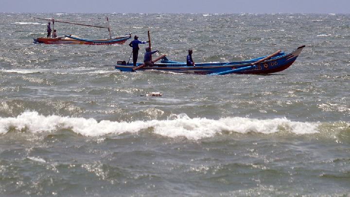
High-Wave Alert Issued for Lombok Strait Waters
Tempatdonasi.com – Maritime activity around the Lombok Strait faces heightened risks in the coming days as stronger winds are expected to generate significant waves across waters in West Nusa Tenggara. The Meteorology, Climatology, and Geophysics Agency (BMKG) has urged vessel operators, fishers, tourism businesses, and coastal communities to pay close attention to changing sea conditions.
The warning covers both the northern and southern stretches of the Lombok Strait, an important passage between Bali and Lombok. Wave conditions may remain elevated for approximately one week, with the most hazardous seas forecast in several waters south of the islands.
Southern Lombok Strait May See Four-Meter Waves
For the next three days, BMKG projects waves of 1.25 to 2.5 meters in the northern Lombok Strait. In the southern part of the strait, waves could rise considerably higher, reaching between 2.5 and 4 meters.
The agency’s marine forecast, valid from 08:00 WITA on October 9 until 08:00 WITA on October 10, 2026, also identifies a 2.5-to-4-meter wave risk in waters south of Lombok Island and south of Sumbawa. Similar conditions are possible in the northern and southern parts of the Alas Strait, as well as in the Indian Ocean south of West Nusa Tenggara.
These wave-height ranges can create difficult conditions for smaller boats and other vessels operating in open or exposed waters. Sea conditions may also change quickly when strong winds persist, making careful planning especially important for anyone traveling or working offshore.
Pressure Pattern Strengthens Winds
Ari Wibianto, head of the Observation, Data, and Information Working Group at the Zainuddin Abdul Madjid Meteorological Station, said the developing conditions are linked to differences in air pressure between Australia and Asia.
A center of relatively high air pressure is currently present near Australia, while pressure over Asia is lower. That contrast can strengthen winds over waters near West Nusa Tenggara, increasing the energy transferred from the atmosphere to the sea surface.
The higher the wind speed, the longer the duration, and the greater the fetch distance, the higher and larger the waves that form.
Fetch distance refers to the stretch of open water over which wind blows without major interruption. When winds are powerful, continue for a longer period, and travel across a broad area of sea, waves can build in both height and force. This is why wind forecasts are a key part of marine safety planning, not only for large commercial vessels but also for fishing craft, tourism boats, and local sea transport.
Coastal and Marine Users Asked to Stay Alert
The Lombok Strait is used by a range of marine activities, from inter-island transportation to fishing and recreation. High waves can affect departure schedules, route choices, docking operations, and activities near beaches or rocky shorelines. People visiting coastal areas should be mindful that rough seas may create stronger currents and more dangerous surf conditions.
BMKG has highlighted the need for extra caution where waves exceed two meters. Maritime operators should monitor the latest weather and sea-state information before departure, while fishers and marine tourism providers should assess whether conditions remain suitable for safe operations.
Users and operators of maritime transport services, fishers, marine tourism operators, and the public engaging in activities in coastal areas should be alert to wave heights exceeding two meters.
For coastal residents and visitors, the warning is a reminder to avoid unnecessary activities close to rough water, particularly when winds increase or wave conditions visibly worsen. Boat passengers can also benefit from checking travel updates directly with operators, as safety decisions and schedule adjustments may be necessary when marine forecasts indicate elevated risk.
The expected pattern does not mean every coastal location will experience identical conditions. Exposure to open seas, local wind direction, and the characteristics of nearby shorelines can influence the severity of waves at a particular site. Still, the projected heights in southern waters and the Indian Ocean zone warrant increased vigilance throughout the affected region.
With high waves forecast across key waters around Lombok and Sumbawa, timely weather checks and practical caution will be essential over the coming week. The strongest focus should remain on the southern Lombok Strait, southern waters off Lombok and Sumbawa, the Alas Strait, and the Indian Ocean south of West Nusa Tenggara.
Related Reading
Frequently Asked Questions
What is BMKG Warns of High Waves in Lombok?
BMKG Warns of High Waves in Lombok is the main topic of this guide. The article explains the context, practical details, and next steps readers should understand.
Why does BMKG Warns of High Waves in Lombok matter?
BMKG Warns of High Waves in Lombok matters because readers are looking for a useful answer, not just a short summary. Good content should match search intent and help them decide what to do next.